Admin
14 May 2015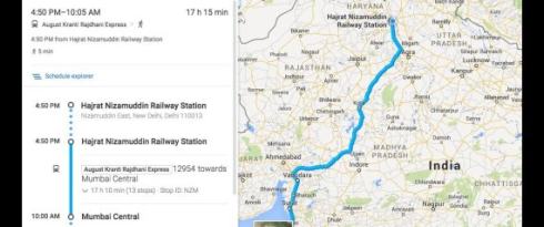
Representational Picture courtesy data.crazyengineers.com
By Ritam Talukdar: Presently Google Maps have been providing services and proper planned public transportation facilities for 2800 cities all across the world. Google maps currently provides right schedules for more than one million transit stops all across the world including in cities like New York, London, Tokyo and Sydney.
Their latest feature known as “Google Transit” will currently provide updated public transport information for eight Indian cities such as Ahmedabad, Bengaluru, Chennai, Hyderabad, Kolkata, Mumbai, New Delhi and Pune. It will mainly provide access to information for 12,000 trains as well as details for bus and metro routes in the selected areas where metro runs.
It is quite user-friendly and one can simply type the name of the destination point in the search bar in Google Maps. On clicking the option of “Get Directions” and the “Public Transport” option will automatically show all the modes available. It will also tell you the approximate time to reach your destination or whether there are any possibilities to cut the time.
According to Suren Ruhela, director and programmer management for Google Maps said that this feature will help people plan public transport trips with ease and quickly. It will be comprehensive and accurate for all the people who ply in buses, trains and metros or trams.
The app is available for Android, iOS and desktop users for free and it has also “Hindi” language feature which can be changed from the user’s smartphone settings. We hope the addition of the Railways Schedules will make it easier for us to plan our next big trip.